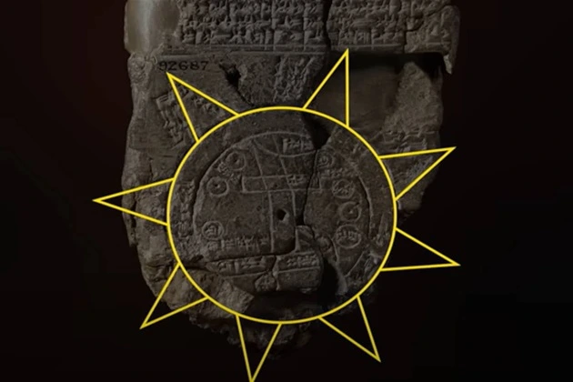
Almost a century and a half ago, a unique clay tablet was discovered in Sippar, an ancient Babylonian city near modern Baghdad. It is called Imago Mundi or “Babylonian World Map.” The age of this artifact is more than 3,000 years old. For many years, scientists have struggled to decipher the cuneiform inscriptions on the back of the map.
Researchers have recently made progress on this issue and reached remarkable conclusions that have become a real scientific breakthrough. The story on the tablet tells about the Great Flood, exactly repeating the story from the Old Testament about Noah’s Ark. What amazing new details have been revealed to historians?
The Babylonian World Map
The unique tablet is no bigger than a human palm and depicts the world’s most ancient map. As the researchers say, if you look closely, you can see a double circle on its flat surface, inside of which there is an inscription in cuneiform that reads: “This is a Bitter River.”
The map shows Babylon, which is surrounded by the waters of the Euphrates River. Several other major cities are also marked there. Visit. A F R I N I K . C O M .For the full article .Beyond the borders of this “known world,” some triangular-shaped objects, presumably mountains or distant, mysterious lands, are depicted on the tablet. Next to them, there is an inscription: “Places full of magic and secrets.” It also says that these are places where there is never sunlight, unknown fruit trees grow, and unknown, wonderful animals walk.
Eight strange geometric shapes appear on the map. They represent a network of areas beyond Babylon’s influence. One of these areas, discovered by scientists in a recent study, resembles a similar story about the flood from the Old Testament.
How does the story of the flood, originally from Babylon, relate to the biblical
The back of this ancient clay tablet contains inscriptions and diagrams. Scientists say that this is a guide to unexplored lands. One inscription on this map tells you how far you must go to reach the fourth triangle. There, you can find “something grandiose, a huge parasite.”
Parsiktu is a very rare term found in Babylonian writings. It was discovered on several other ancient tablets about the Babylonian flood. It means an impressive structure that is visually similar to the ark. It was built by the Babylonian Noah, Utnapishtim, in strict compliance with the instructions given to him by God Ea. He placed his relatives and various animals there to escape the impending Earth disaster.
The Babylonian world map describes how the ark eventually found its home on Urartu mountain. The Old Testament biblical narrative says the same thing. Mount Ararat is mentioned there. Scientists say this is the same mountain; the story is the same. Researchers say that this story was not a myth for the Babylonians. They viewed it as a historical fact. That is why it was reflected in Ancient Babylonian science, geography, and cosmology fields.
The story of Ancient Babylon, which tells about the Great Flood, echoes what is set out in the Bible and similar stories about a worldwide disaster in other Middle Eastern cultures. Interestingly, the story of Gilgamesh and the flood dates back three millennia, and the biblical story dates back five. This highlights how deep the ties between these two civilizations were.
Scientists emphasize that the story of the Great Flood, with all its details, is more than just a legend for the Babylonians. After all, it is very closely intertwined with their cosmology and scientific worldview. The Babylonian world map offers a literal and symbolic representation of this story, suggesting that in Ancient Babylon, it was not a myth at all.
This discovery reveals a striking connection between Babylonian and biblical history, returning to ancient times. Today, this reignites the debate about the truth of Noah’s story as described in the Bible. Turkish scientists have discovered evidence on Mount Ararat that people lived there about 5,000 years ago and that there are remnants of sea clay. The discovery raised questions that scientists needed to remember how existing landscapes were formed. It is quite possible that it was a result of an ancient flood.
However, in this case, Mount Ararat would have appeared only after the flood, making it impossible for the ark to dock there. Today, many researchers view the story of Noah’s Ark as a myth. At the same time, archaeologists make intriguing discoveries repeatedly, forcing the scientific world to consider this story real.
The Babylonian world map not only reveals the veil of mystery over how the ancient civilizations understood the structure of the world and space around them. Imago Mundi testifies that all the Middle Eastern peoples of antiquity had a common cultural memory of the Great Flood. And this memory was immortalized on a 3,000-year-old clay tablet. It is a symbol of how fragile knowledge can be.
