Top 5 strange African borders raise eyebrows
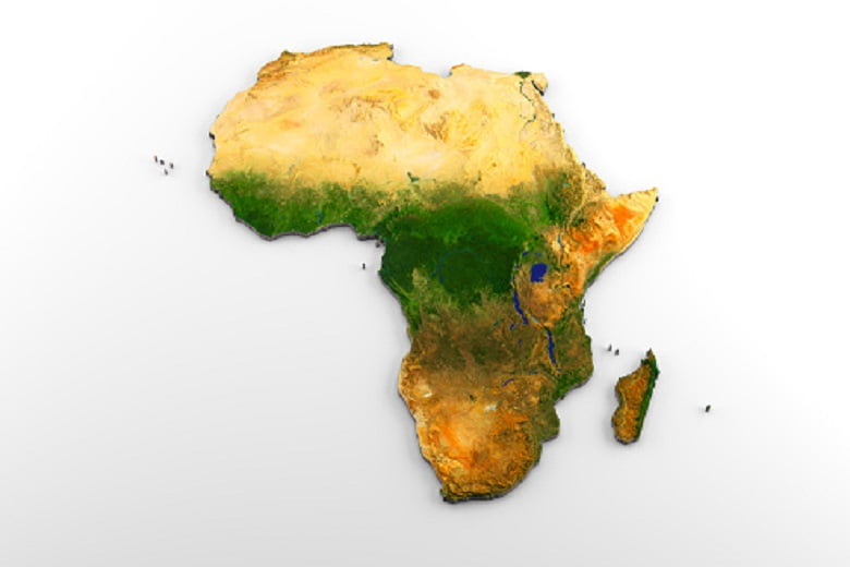
Why is it always so strange in Africa! Some borders in Africa were designed to simplify things, but not all, and if you look at a map, that’s what they do most of the time.
However, Africa is a continent where borders can be quite complicated. The primary reason for this is the colonial era. When European states divided Africa into spheres of influence, literally drawing national borders to suit their interests.
They did this without caring about the people living inside these borders. That is why you will find many peculiar national boundaries in Africa today.
The list of the top 5 crazy Africa borders
1. The world only unclaimed piece of land
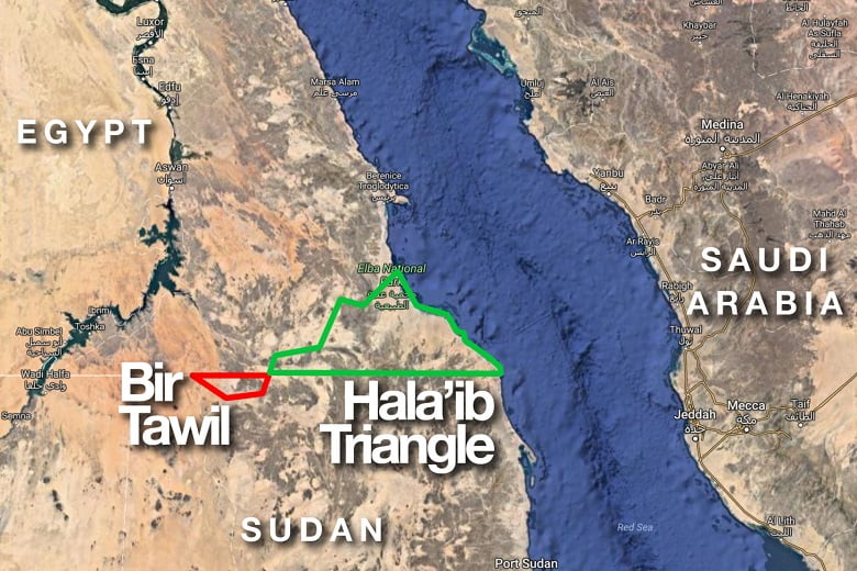
Egypt and Sudan evidently have a common border. It’s just that no one clearly knows where it is. The two countries have different claims on the map, and they both claim rights to the sovereignty of the Hala’ib Triangle.
However, there is also Bir Tawil, which is a piece of land unclaimed by both countries. The sticking point is that neither of them wants to claim Bir Tawil because they would have to give up the much more coveted Hala’ib Triangle if they do.
This dispute goes back to 1899 when Sudan was not yet a country. It was a dispute between Egypt and the British Empire. The border, first established in 1899, is the boundary that the Egyptians claim today. However, as in many other countries, the British drew a new line on the map. They called it the administrative boundary, which Sudan claims today.
2. Crazy border of Zambia and DR Congo
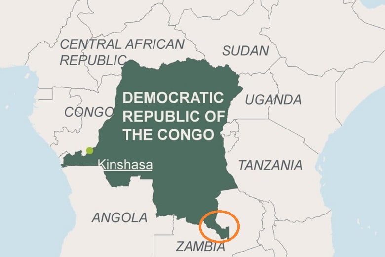
It is known as the Congo Pedicle. This stretch of land cuts over 200 kilometers into Zambia. The strangest thing about this border is how it was created. Belgium colonized the Congo while Zambia was a British colony, and the two sides could not agree on a colonial boundary.
The Belgians wanted access to a rich swampy area where plenty of wild animals lived and hunted for their interest. So they decided to ask the Italians for help. Knowing virtually nothing about the two countries, the Italian king basically drew a line on a map, and all parties agreed that it looked good. This is why this border seems so strange today.
3. South Sudan and Sudan
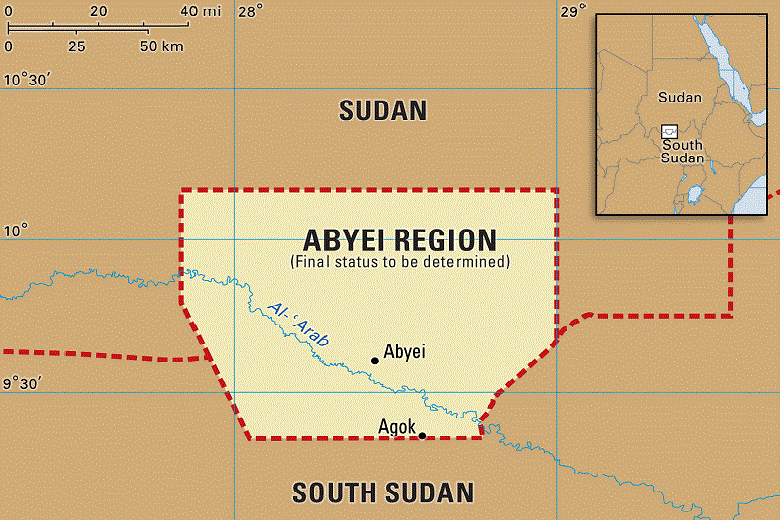
When Sudan was a confederation between Egypt and the British Empire, it was governed by two parts: the north and the south. The North had most of the administrative control, while the south had almost no representation, and the same situation continued after Sudanese independence. This led to a civil war, which ended in 2005.
According to the treaty, South Sudan received a referendum in 2011, after which they gained their independence by almost unanimous decision. With the exception of the Abyei region. Abyei was also supposed to hold a referendum in 2011, but several disputes stopped it. Thus, today, Abyei is still in a limbo state and special administrative status, given a temporary solution.
4. The Namibia Caprivi Strip
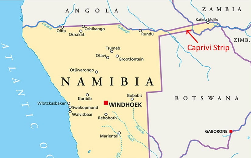
Colonization brought another strange frontier to Africa in the Caprivi Strip, which stretches 450 kilometers into Botswana. The Caprivi Strip was named after the German Chancellor Leo von Caprivi. He wanted the German colony’s boundary to cross the Zambezi River so that the Germans could use it to navigate to the east coast of Africa.
In a treaty with Britain, the Germans gave up any rights to Zanzibar in exchange for this tiny piece of land known today as the Caprivi Strip.
Moreover, if you look at an ethnic map of Africa, you will see that this strip covers many different ethnic groups speaking different languages. Of course, those ethnic group wasn’t taken into account in the creation of this boundary.
Unfortunately, the Zambezi River has some of the biggest waterfalls and is practically not navigable, making the end-result almost useless.
5. Senegambia border
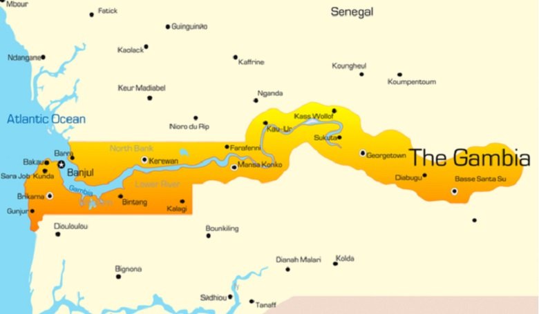
France and Britain began to explore and trade along the coast of West Africa from the 17th century, and the two powers vied for supremacy in the Senegambian region over the following centuries. In 1821, Britain established a formal colony on the coast of modern-day Gambia, threatening nearby French coastal settlements.
In the 1880s, there was fierce competition between European powers for territory in Africa – a process known as “Scramble for Africa”. This process culminated in the Berlin Conference of 1884, at which the European powers concerned agreed on their territorial claims and rules for further action.
On 10 August 1889, France and Britain signed a treaty delimiting the Gambia and Senegal border, extending the Gambia as far east as Yarbutenda. Various poles were erected to mark the land border, and further demarcation was carried out in 1911 and 1925.
In 1960, France granted Senegal independence; The Gambia became independent in 1965, after which the border between the two sovereign states became international. In 1976, the two governments made some minor border adjustments on the far eastern section by mutual agreement.