What is the oldest map in the world tells scientists? Map of Babylonian empire
At the end of the 19th century, during excavations of the ancient city of Sippar (ancient Mesopotamia), an Assyrian archaeologist named Ormuzd Rassam discovered the majestic Temple of the Sun. This place is located just 30 kilometers southwest of Baghdad and 69 kilometers north of Babylon.
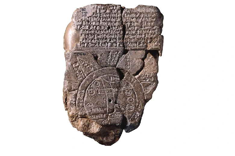
Now, this city is called Tell Abu-Habbah. Fifty thousand clay tablets with cuneiform writing were found in an ancient temple! Among this host of priceless historical artifacts from the era of ancient Babylon, one tablet stood out in particular. It had a map of the world on it. The first world map in history!
Unique plaque
All clay tablets contained incredibly valuable information about ancient history and the Babylonian empire. One was a detailed map of the Ancient World. Now, this artifact is stored in the British Museum along with the rest of the tablets.
The text was deciphered by experienced assyriologists. The drawing is a cartographic representation of the world as it was known in ancient Mesopotamia. In fact, there are many Babylonian maps, because it was an extremely advanced civilization, but this map is unique in that it is global—one of a kind.
The artifact dates from the 6th century BC. This is the time that historians call the period of the Neo-Babylonian Empire before the conquest by Cyrus the Great. This is the period when the great state of Babylon was at the peak of its development, it was the true center of the universe. This is evidenced by the ancient map.
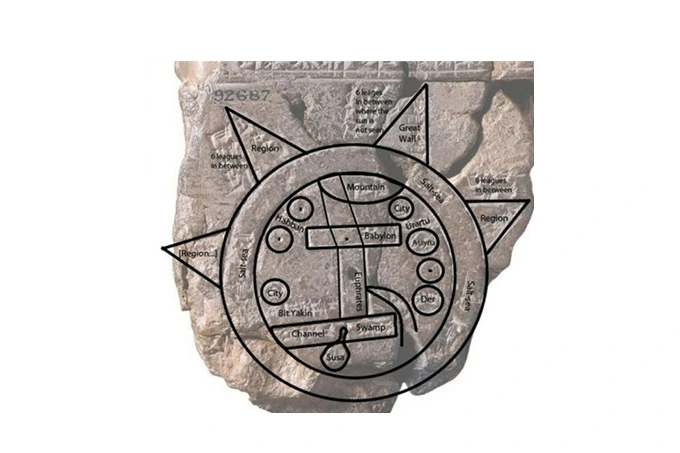
It, in turn, is a copy of an older map that dates back to the 9th century BC. The world here is depicted as a disk with a ring of water around it. The world ocean is here called bitter waters. Babylon is indicated by a rectangle on the extreme right bank of the Euphrates.
In fact, the city was located on both banks of the river. Its waters flow south to a certain horizontal strip, the right end of which is marked as a “swamp”, and the left one as a “mouth”. Perhaps the swamp is the source of the Shatt al-Arab river. The curved line from the north most likely represents the Zagros Mountains.
World map
Small circles on the map represent cities or regions. Two of them are identified as Assyria and Der. The territory of the Aramaic tribe of Bit-Yakin is located at the mouth of the Euphrates, and Habban, the capital of the Kassites, is mistakenly located to the west of Babylon. To the north of Assyria, the kingdom of Urartu is indicated, and to the south – is Susa, the capital of Elam. Beyond the round bitter river lie eight outlying regions depicted as triangles. Perhaps this was done to indicate that they were mountainous. Near the northwest is written, “where Shamash is not seen”. This fully reflects the Babylonian belief that the sun rises in the east, sets in the west, and then returns to the east through the waters of the underworld.
Other elements of the map have not yet been identified. Some are known to represent cities, but no Assyriologist has been able to name them. It was also not possible to identify circles with dots in the center.
Some scholars believe that these could be cities that were already in ruins by the time the map was compiled. The reverse side of the map describes these eight regions and indicates the distance between them. The last paragraph says: in the eight regions of the four shores of the Earth, no one knows her insides. The four shores were a common expression in Mesopotamia for the entire inhabited world.
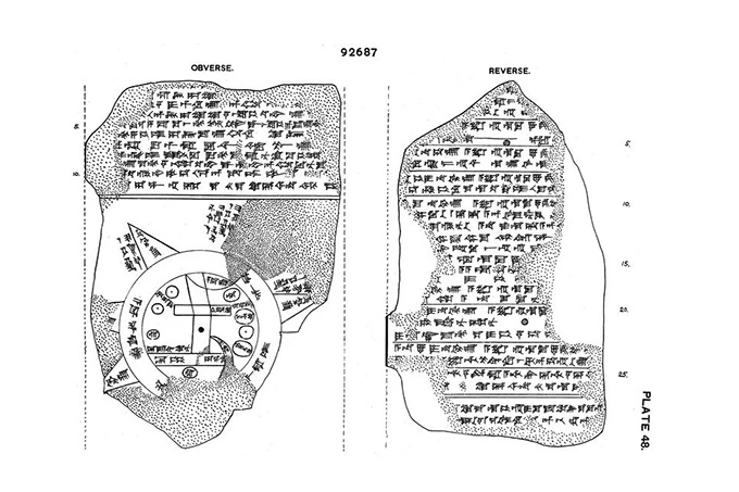
The most interesting thing is that this text absolutely does not correspond to the front side of the tablet. It describes that the world was created by Marduk, the chief god of Babylon. It also says that he defeated all the rest and placed them in the sea. These gods are a viper and a huge sea serpent.
The narrative tells that their destroyed statues were sent to the bottom of the sea, that is, to the underworld. The following describes a few more myths about the Anzu bird. It was among the Babylonians the deity of the wind and thunderstorm in the form of a bird-man. It stole the tablet of fate from Enlil, the father of the gods.
About 15 different animal species are described next: a goat, a gazelle, a zebu, a leopard, a bison, a lion, a wolf, a deer, a monkey, an ostrich, a cat, a chameleon, a hyena, and also an animal that Marduk created over the ripples of the sea (possibly a whale). Interestingly, local animals are only cats and zebu, and all the rest represent remote regions.
A little lower is the biography of Sargon I of Akad, the founder of the Akkadian Empire in 2270 BC. The story tells about his wars with Nur-Dagan, the king of Purushand (this is the center of modern Turkey). It also tells about the sage Utnapishtim, who was visited by Gilgamesh in the famous Mesopotamian poem, in a country beyond the sea and the Waters of Death.
What all this has to do with the world map is not entirely clear. But scientists are far from deciphering everything yet. Most likely, there are many surprises hidden there. Experts say the map is a bird’s-eye view of the Earth. The tablet says that these are four quadrants into which the world is divided, and no one knows how far, because they are endless. The last lines of the tablet speak of the author who created it. It says that this was done by the son of Ishsuru, a descendant of Ea-bel-il, from an old copy.
The mysteries of the ancient world beckon the minds of scientists. It is not always possible to solve them. Read, for example, our other article about what Plato encrypted in his texts about Atlantis, or the Secret of the first highly developed civilization on Earth.