How ancestors saw the Earth: Ancient geographical maps of the strangest shapes
The first geographical maps appeared on earth almost simultaneously with the emergence of a person’s drawing skills. True, these were not maps but their distant prototypes.
Still, one thing is clear: as soon as a person began to move long distances, he began to try to comprehend his movement and, having a natural spatial sense, attempted to display this in drawings. Maps in a more or less familiar form appeared much later and incredibly long ago – even before our era.
The prototype of the ancient map
Initially, the “ancestors” of the cards looked like schematic drawings on the walls of caves, dwellings, ancient dishes (for example, plates), stone slabs.
For example, this “star” mural, found by archaeologists, was created in ancient Jordan and is, according to scientists, a cosmological map. In the center is the “known world,” “first ocean,” “second world,” and “second ocean.” From eight points, which most likely symbolized the islands, the “beyond world” and “a heavenly ocean.” The rectangle located at the bottom right, according to historians, is irrelevant – this is a drawing of a building (possibly a temple).
The oldest map of the world
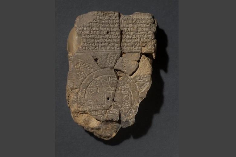
One of the first surviving maps known to scientists is an ancient relic found in Iraq. This map, which gained great fame and influenced people’s ideas about the world, was created in Babylon.
As you might guess, the world is depicted as flat, round, and its center is, as you might guess, Babylon itself. The image found on a piece of clay slab is dated to the 7th century BC.
Anaximander was ahead of his time
A real breakthrough in geography and cartography occurred when the map compiled by Anaximander of Miletus (610 – 540 BC) appeared. He imagined the earth in the form of an oval, which is elongated from east to west.
Anaximander, whom Aristotle himself respected and considered a great sage, was a geographer and an astronomer. He tried to compare the earth with other space objects and pondered a lot about the origin of the Universe, concluding that it is born, reaches the peak of its development, dies, and then revives again.
Neither the map of the world drawn by Anaximander nor its copies have survived to this day, but Herodotus wrote that the ancient scientist depicted the world on it in the form of a drum, around which the ocean is located.
Information about the map of Hecataeus of Miletus, who lived about the same period, but a little later, has reached our days. According to her, the world consists of three parts – Europe, Asia, and Libya. All three “continents” are located around the Mediterranean Sea. His map was made based on data from Anaximander.
In his work “Etymology” (VII century), the encyclopedist priest Isidore of Seville portrayed such an idea of the world very similarly. The “T” shape represents the sea, and the “O” represents the ocean. And there is already Africa here.
The father of geography (in fact, he was the first to introduce this term) is considered Eratosthenes, who in the II century BC. wrote a three-volume work, which was called “Geography.” It indicated that the earth has the shape of a ball, and the scientist confirmed this statement with his mathematical calculations. Alas, in its original form, this work did not reach modern scholars – it is known about it from the retellings of Roman authors. Also, the map of Eratosthenes has not survived, but it had an invaluable influence on the studies of medieval geographers.
By the way, it was Eratosthenes who became the first to mark the meridians on the maps – however, these designations were not yet so accurate. And it was he who divided the world into five climatic zones.
The most interesting ancient maps
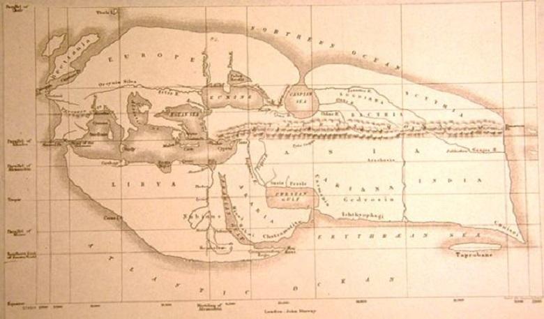
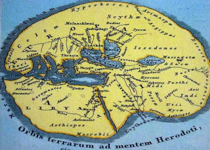
But such a map was created in 400 BC by the historian Herodotus:
The map of Pomponius Mela – the earliest Roman geographer who wrote the scientific work “Descriptive Geography” – divides the earth into five zones, three of which are uninhabited.
Mela believed that the southern lands of our planet were inaccessible to the northerners since they were separated from the temperate latitudes by an arid territory of unbearable heat.
Like many predecessors, he considered the Caspian Sea to be the gulf of the Northern Ocean. And this is not surprising because in 43 when Pomponius Mela created his work, most of our planet was not studied.
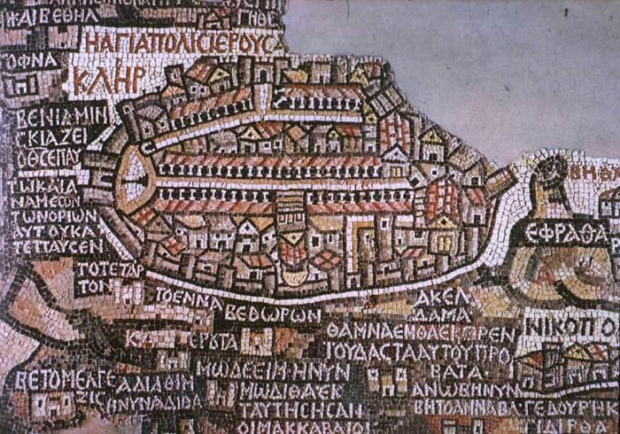
Another exciting find is a mosaic map discovered in Madaba (Jordan) during archaeological excavations of the early Christian church of St. George, which represents ancient Jerusalem. The panel was made around the 6th century. It depicts churches and other structures.
They are shown so realistically that modern scientists could identify them – for example, the Church of the Holy Sepulcher located in the center is visible. According to scientists, this is the oldest map of the Holy Land.
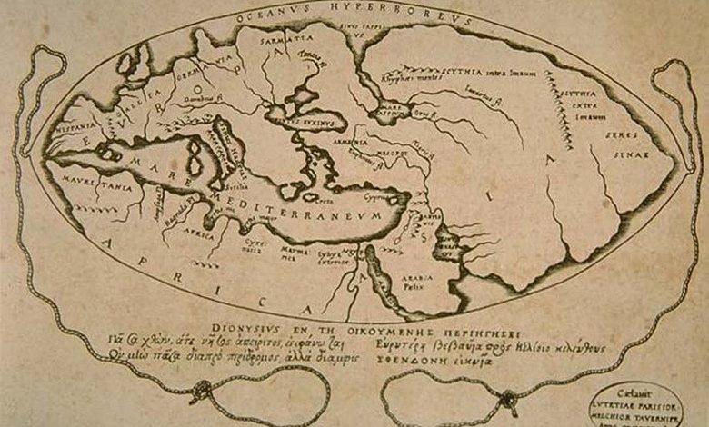
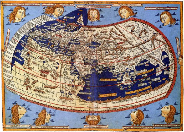
Ptolemy’s map as a reference point for posterity
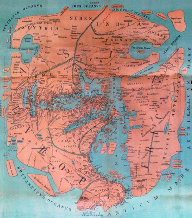
The great scientist did excellent work from Alexandria Claudius Ptolemy. In about AD 150, he drew up a map of the world, to which about 30 more separate, more detailed maps were attached. The entire treatise was called The Guide to Geography.
Ptolemy marked the location of even very remote zones – from Egypt to the Scandinavian lands and from the Atlantic to Indochina. This relic was discovered many centuries later, and for a long time, up to the era of geographical discoveries, it was the main cartographic document for travelers and scientists. Subsequently, it was improved.
Continents such as Asia, Europe, and Africa became more formalized on the revised map, and Jerusalem was indicated as the center of the world instead of Babylon.
Ptolemy’s map is divided into equal parts by parallels and meridians. The Mediterranean and the Middle East are portrayed more or less correctly, but Ptolemy’s knowledge of other lands becomes vaguer as Ptolemy moves further south.
For example, he designates the Indian Ocean as an inland sea, and the unexplored part of the African continent in the south expands and surrounds it, connecting with Asia. There is no idea about Antarctica yet – it is “uncharted land.” Well, Asia, in his opinion, was so huge that it even occupied the territory on which, as it turned out many years later, the Pacific Ocean is located.
Recently, the University of Chicago digitized all ancient maps and published a six-volume work on the history of geography and cartography with explanations. This large-scale project on ancient cartography began in the 1980s and, possibly, it will still be complemented by new archaeological and historical finds.