How were the Nazca lines made? Figures of the Palp Plateau
Figures of the Palp Plateau: What mysteries do the drawings hold that predate the ancient geoglyphs of Nazca
The deserted Palp Plateau in Peru has become the site of a stunning archaeological find. In this bleak place, located 20 kilometres from the more famous Nazca plateau, they also found enormous geometric patterns and lines visible only from the air. Interestingly, the figures in Palpa are different from their “neighbours” in Nazca. First, they are smaller. Secondly, several scientists believe that they may be older.
During a survey of the area near the Peruvian city of Palpa, many geoglyphs were identified, which are older than their famous neighbours in Nazca. Luis Jaime Castillo, Johny Isla, and others say these images appear to have been intended for a completely different audience than the Nazca line.
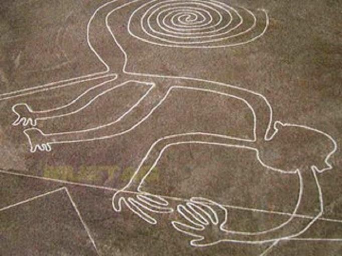
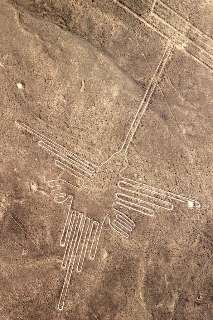
The unusual lines and images of animals that dot the Nazca plateau in Peru are known worldwide. However, in the north of the country, in the vicinity of the modern city of Palpa, you can also find many quite different geoglyphs. Usually, these are compositions of human figures or creatures. Researchers believe that this is the work of the Paracas culture, which has existed since 800 BC. up to 100 BC. If this is the case, then the Palp drawings were probably created before their famous neighbours, attributed to the Nazca culture, which existed from about 1 to 650 AD. The presence of these two different styles of geoglyphs makes it possible to compare and contrast the methods of creating such images.
Between November 2017 and April 2018, extensive aerial surveys of the mountain slopes around the city of Palpa were carried out to find and document the geoglyphs. This work was carried out in cooperation with the Ministry of Culture to identify archaeological features and their protection. The study was funded in part by the National Geographic Society through the GlobalXplorer program, which aims to validate the findings found by amateur archaeologists. Several new examples of Palp’s figures were successfully discovered during the study and the analysis of such places.
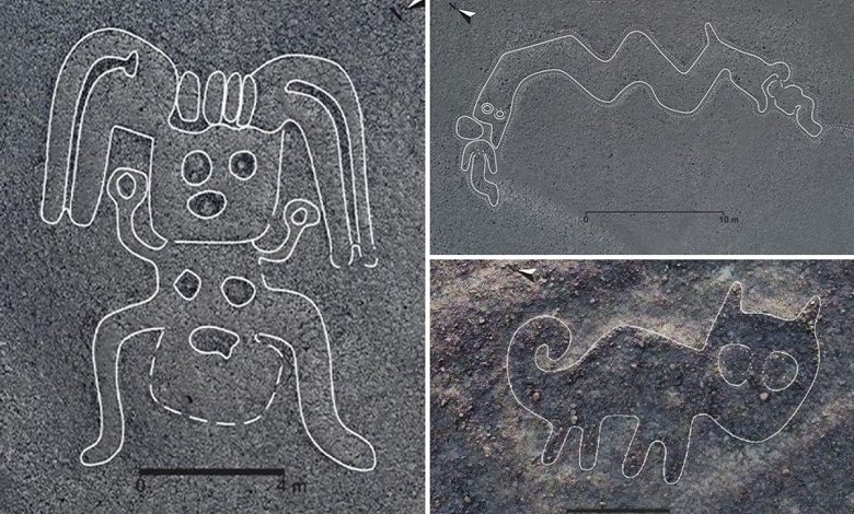
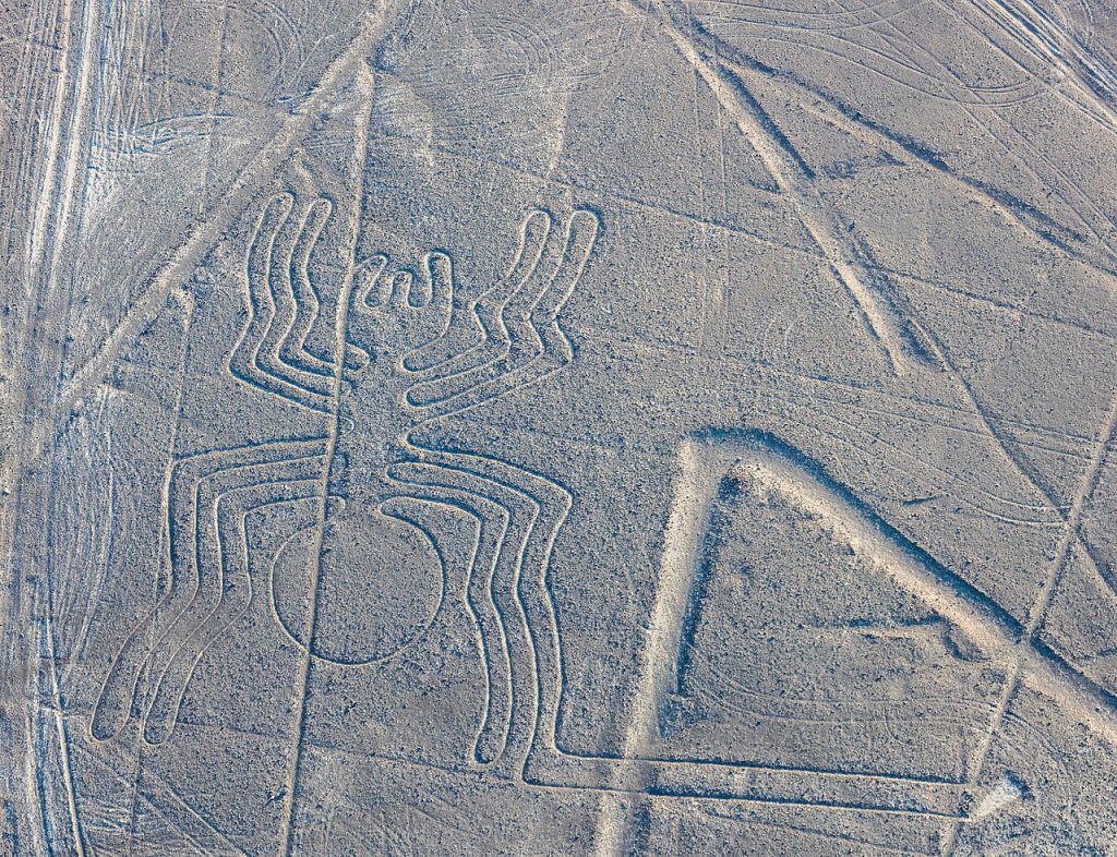
These two examples of Palpa figures discovered during a recent drone survey show a clear difference from the Nazca lines.
The fieldwork was carried out by a group of Peruvian archaeologists led by Luis Jaime Castillo from the Catholic University of Lima and Johny Isla from the Peruvian Ministry of Culture. Exploring this vast region with low “mesa” (flat-topped hills and steep slopes) as well as mountain slopes required a systematic aerial survey, which was the first time.
The drones flew at low altitudes and took thousands of photographs, which were then processed using photogrammetry software. This approach has allowed the creation of highly detailed and accurate 3D models and 2D orthophotographs – that is, images displayed at a uniform scale accurately capture even the most minor wrinkles on the surface. Just like in the neighbouring Nazca region, Palpa’s climate is very arid.
Indeed, there is almost no rain here; therefore, surface changes can remain visible for millennia. In creating both the Palpa figures and the later Nazca lines, the same technique was used, which was to remove the dark stones covering the ground to expose the lighter soil beneath. This technique, combined with the arid climate, meant that the people who created the Palp figures can still be seen today.
Surveys and photographs were carried out using small, fully automated uncrewed aerial vehicles flying at an altitude of 20 to 50 meters. Their flight path was set using autopilot software that controlled length, speed, camera position, photo overlap, and so on. In this regard, the project was indeed a proof of concept, aimed at demonstrating that drone footage can be an effective means of finding previously unknown archaeological features.
Most of Palpa’s figures were made in specific areas of the landscape, especially on the mesa slopes (hills). Naturally, these are also areas where, due to the steepness of the terrain and the remoteness of the location, there are very few animals and people, which contributes to the preservation of the drawings. Of course, such images, made by a simple method of moving stones, can be easily destroyed by rainwater flowing down from the flat tops of the mezes.
Fortunately, there is so little rain in this ultra-arid environment that there is not enough rain to create running water. Therefore, even though thousands of years have passed since creating the drawings, the unique images still amaze scientists.